
파일:1827 Finley Map of Vermont - Geographicus - Vermont-finely-1827.jpg

미리 보기 크기: 471 × 600 픽셀 다른 해상도: 188 × 240 픽셀 | 377 × 480 픽셀 | 603 × 768 픽셀 | 804 × 1,024 픽셀 | 2,356 × 3,000 픽셀
원본 파일 (2,356 × 3,000 픽셀, 파일 크기: 1.78 MB, MIME 종류: image/jpeg)
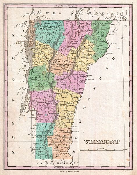
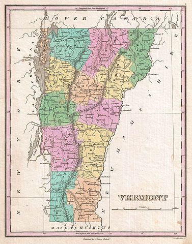
| Anthony Finley: Vermont.
( |
||||||
|---|---|---|---|---|---|---|
| 화가 | ||||||
| 제목 |
Vermont. |
|||||
| 설명 |
English: A beautiful example of Finley's important 1827 map of Vermont. Depicts the state with moderate detail in Finley's classic minimalist style. Shows river ways, roads, canals, and some topographical features. Offers color coding at the county level. Title and scale in lower right quadrant. It is very uncommon to find an early 19th century exclusively depicting Vermont, as most maps of the period bundled it with New Hampshire. Identifies Killington Peak and Camel's Hump, now popular ski resorts. Engraved by Young and Delleker for the 1827 edition of Anthony Finley's General Atlas . |
|||||
| 날짜 | 1827년 (undated) | |||||
| 크기 | 높이: 11.5 in (29.2 cm); 너비: 9 in (22.8 cm) | |||||
| 일련 번호 |
Geographicus link: Vermont-finely-1827 |
|||||
| 출처/촬영자 |
Finley, Anthony, A New General Altas, Comprising a Complete Set of Maps, representing the Grand Divisions of the Globe, Together with the several Empires, Kingdoms and States in the World; Compiled from the Best Authorities, and corrected by the Most Recent Discoveries, Philadelphia, 1827.
|
|||||
| 저작권 (이 파일을 인용하기) |
|
|||||
파일 역사
날짜/시간 링크를 클릭하면 해당 시간의 파일을 볼 수 있습니다.
| 날짜/시간 | 섬네일 | 크기 | 사용자 | 설명 | |
|---|---|---|---|---|---|
| 현재 | 2011년 3월 23일 (수) 17:55 | | 2,356 × 3,000 (1.78 MB) | BotMultichillT | {{subst:User:Multichill/Geographicus |link=http://www.geographicus.com/P/AntiqueMap/Vermont-finely-1827 |product_name=1827 Finley Map of Vermont |map_title=Vermont. |description=A beautiful example of Finley's important 1827 map of Vermont. Depicts the st |
이 파일을 사용하는 문서
다음 문서 1개가 이 파일을 사용하고 있습니다:
이 파일을 사용하고 있는 모든 위키의 문서 목록
다음 위키에서 이 파일을 사용하고 있습니다:
- bn.wikipedia.org에서 이 파일을 사용하고 있는 문서 목록
- en.wikipedia.org에서 이 파일을 사용하고 있는 문서 목록
- ja.wikipedia.org에서 이 파일을 사용하고 있는 문서 목록
- uk.wikipedia.org에서 이 파일을 사용하고 있는 문서 목록