
파일:Achaemenid Empire 500 BC.png

미리 보기 크기: 800 × 427 픽셀 다른 해상도: 320 × 171 픽셀 | 640 × 341 픽셀 | 1,024 × 546 픽셀 | 1,280 × 683 픽셀 | 3,070 × 1,637 픽셀
원본 파일 (3,070 × 1,637 픽셀, 파일 크기: 811 KB, MIME 종류: image/png)
파일 설명
| 설명 |
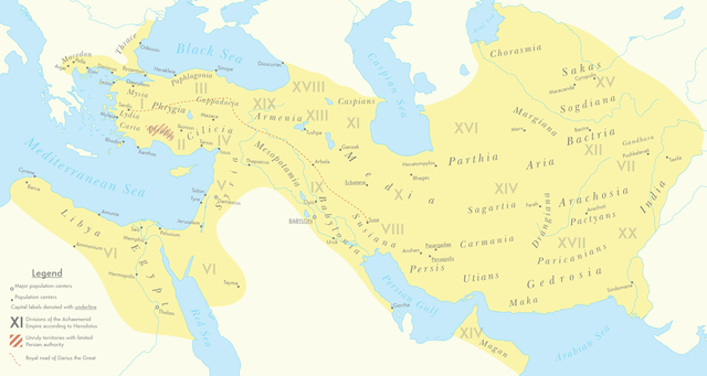
English: A map of the Achaemenid Empire around 500 BC featuring ancient regions, settlements and Satrapies. This map assembles information from the Historischer Schul-Atlas zur alten, mittleren und neueren Geschichte by Heinrich Kiepert and Carl Wolff from 1879 as accessed from GEI Digital, the 1923 edition of Historical Atlas by William R. Shepherd as accessed from the Perry-Castañeda Library's online map collection and Livius.org's article on the Satrapies of the Achaemenid Empire according to Herodotus. |
| 날짜 | |
| 출처 | 자작 |
| 저자 | Cattette |
라이선스
나는 아래 작품의 저작권자로서, 이 저작물을 다음과 같은 라이선스로 배포합니다:
이 파일은 크리에이티브 커먼즈 저작자표시 4.0 국제 라이선스로 배포됩니다.
- 이용자는 다음의 권리를 갖습니다:
- 공유 및 이용 – 저작물의 복제, 배포, 전시, 공연 및 공중송신
- 재창작 – 저작물의 개작, 수정, 2차적저작물 창작
- 다음과 같은 조건을 따라야 합니다:
- 저작자표시 – 적절한 저작자 표시를 제공하고, 라이센스에 대한 링크를 제공하고, 변경사항이 있는지를 표시해야 합니다. 당신은 합리적인 방식으로 표시할 수 있지만, 어떤 방식으로든 사용권 허가자가 당신 또는 당신의 사용을 지지하는 방식으로 표시할 수 없습니다.
파일 역사
날짜/시간 링크를 클릭하면 해당 시간의 파일을 볼 수 있습니다.
| 날짜/시간 | 섬네일 | 크기 | 사용자 | 설명 | |
|---|---|---|---|---|---|
| 현재 | 2021년 3월 12일 (금) 16:01 | | 3,070 × 1,637 (811 KB) | Cattette | Changed terminology, added Cyropolis |
| 2021년 3월 9일 (화) 15:05 |  | 3,070 × 1,637 (811 KB) | Cattette | Added more cities | |
| 2021년 3월 9일 (화) 06:52 |  | 3,070 × 1,637 (807 KB) | Cattette | Removed anachronistic labels, removed Thrace and Macedonia as Satrapies | |
| 2021년 3월 9일 (화) 05:44 |  | 3,070 × 1,637 (813 KB) | Cattette | Fixed north eastern border, tweaked satrapies | |
| 2021년 3월 9일 (화) 03:55 |  | 3,070 × 1,637 (794 KB) | Cattette | Tweaked borders and satraps | |
| 2021년 3월 9일 (화) 00:20 |  | 3,070 × 1,637 (789 KB) | Cattette | Fixed Indian border again, added cities in Greece | |
| 2021년 3월 8일 (월) 16:02 |  | 3,070 × 1,637 (785 KB) | Cattette | Stronger color, capitals, more cities, added Indian territories beyond the Indus | |
| 2021년 3월 7일 (일) 23:26 |  | 2,923 × 1,637 (729 KB) | Cattette | Uploaded own work with UploadWizard |
이 파일을 사용하는 문서
다음 문서 1개가 이 파일을 사용하고 있습니다:
이 파일을 사용하고 있는 모든 위키의 문서 목록
다음 위키에서 이 파일을 사용하고 있습니다:
- arz.wikipedia.org에서 이 파일을 사용하고 있는 문서 목록
- ast.wikipedia.org에서 이 파일을 사용하고 있는 문서 목록
- ceb.wikipedia.org에서 이 파일을 사용하고 있는 문서 목록
- cs.wikipedia.org에서 이 파일을 사용하고 있는 문서 목록
- en.wikipedia.org에서 이 파일을 사용하고 있는 문서 목록
- fa.wikipedia.org에서 이 파일을 사용하고 있는 문서 목록
- ga.wikipedia.org에서 이 파일을 사용하고 있는 문서 목록
- gl.wikipedia.org에서 이 파일을 사용하고 있는 문서 목록
- ha.wikipedia.org에서 이 파일을 사용하고 있는 문서 목록
- he.wikipedia.org에서 이 파일을 사용하고 있는 문서 목록
- ku.wikipedia.org에서 이 파일을 사용하고 있는 문서 목록
- pl.wikipedia.org에서 이 파일을 사용하고 있는 문서 목록
- ps.wikipedia.org에서 이 파일을 사용하고 있는 문서 목록
- tg.wikipedia.org에서 이 파일을 사용하고 있는 문서 목록
- www.wikidata.org에서 이 파일을 사용하고 있는 문서 목록