
파일:Lituyabay Earth Observatory image 2020.jpg
최대 해상도입니다.
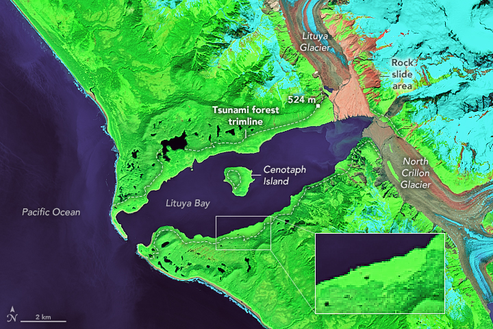
Lituyabay_Earth_Observatory_image_2020.jpg (720 × 480 픽셀, 파일 크기: 489 KB, MIME 종류: image/jpeg)
파일 설명
| 설명 | NASA Earth Observatory image by Lauren Dauphin, using Landsat data from the U.S. Geological Survey | |||||
| 날짜 | ||||||
| 출처 | https://earthobservatory.nasa.gov/images/147557/lituya-bays-apocalyptic-wave?src=eoa-iotd | |||||
| 저자 | Lauren Dauphin, NASA Earth Observatory | |||||
| 저작권 (이 파일을 인용하기) |
|

파일 역사
날짜/시간 링크를 클릭하면 해당 시간의 파일을 볼 수 있습니다.
| 날짜/시간 | 섬네일 | 크기 | 사용자 | 설명 | |
|---|---|---|---|---|---|
| 현재 | 2020년 11월 26일 (목) 15:36 | | 720 × 480 (489 KB) | Tillman | {{Information |Description= NASA Earth Observatory image by Lauren Dauphin, using Landsat data from the U.S. Geological Survey |Source= https://earthobservatory.nasa.gov/images/147557/lituya-bays-apocalyptic-wave?src=eoa-iotd |Date= July 1, 2020 |Author= Lauren Dauphin, NASA Earth Observatory |Permission= {{PD-USGov-NASA}} |other_versions= }} Category:Files uploaded by PDTillman Category:Lituya Bay megatsunami |
이 파일을 사용하는 문서
다음 문서 1개가 이 파일을 사용하고 있습니다:
이 파일을 사용하고 있는 모든 위키의 문서 목록
다음 위키에서 이 파일을 사용하고 있습니다:
- en.wikipedia.org에서 이 파일을 사용하고 있는 문서 목록
- it.wikipedia.org에서 이 파일을 사용하고 있는 문서 목록
- no.wikipedia.org에서 이 파일을 사용하고 있는 문서 목록
- vi.wikipedia.org에서 이 파일을 사용하고 있는 문서 목록