
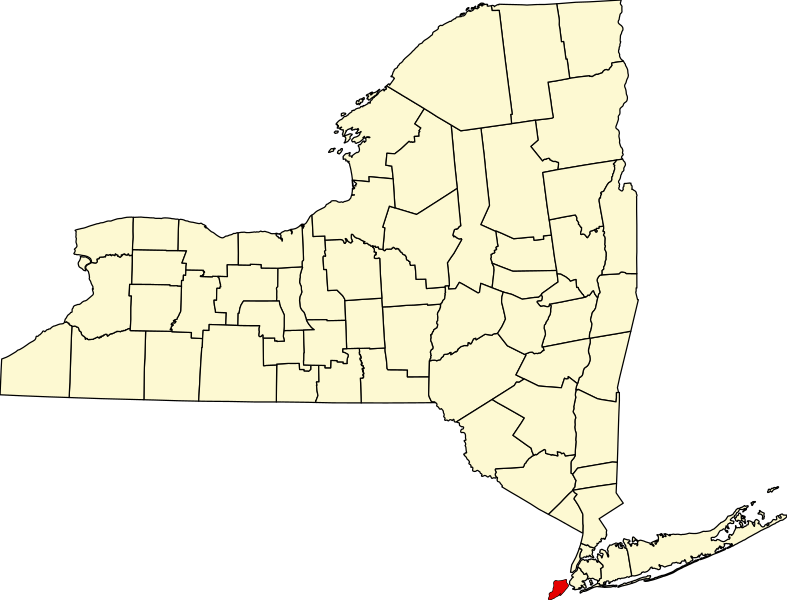
파일:Map of New York highlighting Richmond County.svg

SVG 파일의 PNG 형식의 미리보기 크기: 787 × 600 픽셀. 다른 해상도: 315 × 240 픽셀 | 630 × 480 픽셀 | 1,008 × 768 픽셀 | 1,280 × 976 픽셀 | 2,560 × 1,951 픽셀 | 6,599 × 5,030 픽셀
원본 파일 (SVG 파일, 실제 크기 6,599 × 5,030 픽셀, 파일 크기: 112 KB)
파일 설명
| 설명 |
English: This is a locator map showing Richmond County in New York. For more information, see Commons:United States county locator maps. |
| 날짜 | |
| 출처 |
자작: English: The maps use data from nationalatlas.gov, specifically countyp020.tar.gz on the Raw Data Download page. The maps also use state outline data from statesp020.tar.gz. The Florida maps use hydrogm020.tar.gz to display Lake Okeechobee. |
| 저자 | David Benbennick |
라이선스
| 나는 이 작품의 저작권자로서, 이 작품을 퍼블릭 도메인으로 모두에게 공개합니다. 이 공개 선언은 전 세계적으로 유효합니다. 만약 저작권의 포기가 법률적으로 가능하지 않은 경우, 나는 이 작품을 법적으로 허용되는 한도 내에서 누구나 자유롭게 어떤 목적으로도 제한없이 사용할 수 있도록 허용합니다. |
파일 역사
날짜/시간 링크를 클릭하면 해당 시간의 파일을 볼 수 있습니다.
| 날짜/시간 | 섬네일 | 크기 | 사용자 | 설명 | |
|---|---|---|---|---|---|
| 현재 | 2006년 2월 13일 (월) 00:33 | | 6,599 × 5,030 (112 KB) | David Benbennick | {{subst:User:Dbenbenn/clm|county=Richmond County|state=New York|type=county}} |
이 파일을 사용하는 문서
다음 문서 3개가 이 파일을 사용하고 있습니다:
이 파일을 사용하고 있는 모든 위키의 문서 목록
다음 위키에서 이 파일을 사용하고 있습니다:
- azb.wikipedia.org에서 이 파일을 사용하고 있는 문서 목록
- bpy.wikipedia.org에서 이 파일을 사용하고 있는 문서 목록
- cy.wikipedia.org에서 이 파일을 사용하고 있는 문서 목록
- de.wikipedia.org에서 이 파일을 사용하고 있는 문서 목록
- en.wikipedia.org에서 이 파일을 사용하고 있는 문서 목록
- List of counties in New York
- Richmondtown, Staten Island
- Isle of Meadows
- Prall's Island
- Stapleton Heights, Staten Island
- Castleton, Staten Island
- Arrochar, Staten Island
- Richmond Creek (Fresh Kills)
- Wikipedia:WikiProject New York City
- Annadale, Staten Island
- Richmond Valley, Staten Island
- Bay Terrace, Staten Island
- Sunnyside, Staten Island
- Concord, Staten Island
- Meiers Corners, Staten Island
- Ward Hill, Staten Island
- Emerson Hill, Staten Island
- Egbertville, Staten Island
- Greenridge, Staten Island
- Randall Manor, Staten Island
- Shore Acres, Staten Island
- Brighton Heights, Staten Island
- Port Ivory, Staten Island
- National Register of Historic Places listings in Staten Island
- Aspen Knolls
- Manor Heights, Staten Island
- Tappen Park
- Long Pond Park
- Bloomingdale Park
- Wolfe's Pond Park
- New Creek (Staten Island)
- Template:StatenIsland-geo-stub
- Willowbrook Park
- Arlington, Staten Island
- Chelsea, Staten Island
- Old Place, Staten Island
- Southfield, Staten Island
- Middletown, Staten Island
- Westfield, Staten Island
- Northfield, Staten Island
- Fresh Kills
- Tompkins Circle
- Ingram Woods
- User:AridCeption/sandbox
이 파일의 더 많은 사용 내역을 봅니다.